Description
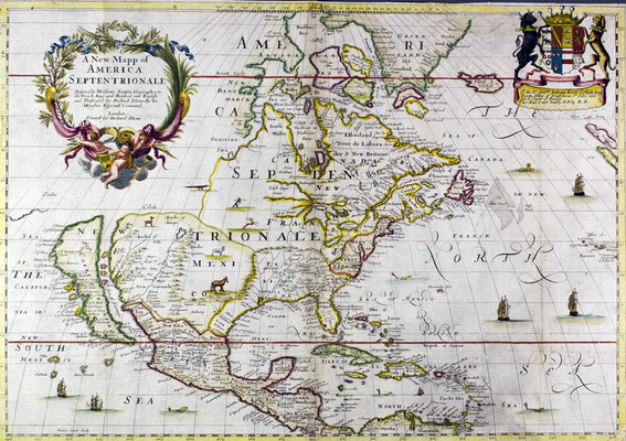
Richard Blome’s map of North America contains exquisite details and exquisite flaws. Blome’s map, first published in 1668, was based on a map published in 1650 by French cartographer Nicolas Sanson.
Blome’s map included some significant improvements over Sanson’s original, including better mapping of Newfoundland and the mid-Atlantic region, and the naming of Maryland and New York. And the 1682 edition of Blome’s map, featured here, included further updates and improvements, including the naming of the colony of Carolina and inclusion of Charlestown.
But perhaps the most notable feature of Blome’s map to the modern eye is his representation of California as an island.
Blome was not alone in depicting California separated from the rest of the North American continent. The misconception appears to have begun as a result of Friar Antonio de la Ascension’s written account of Sebastian Vizcaino’s 1602 to 1603 expedition. The misrepresentation is believed to have first appeared on a printed map by Henry Briggs in 1625 in a widely read London publication called Purchas His Pilgrimes by Samuel Purchas. Briggs’s map includes a legend that reads, “California sometimes supposed to be a part of the western continent, but since by a Spanish chart taken by the Hollanders it is found to be a goodly island.”
California was confirmed to be part of the North American continent as early as 1698, but mapmakers continued representing it as an island for decades because people were accustomed to seeing it portrayed that way, as is evidenced Richard William Seale’s 1745 Map of North America located two maps to the right from Blome’s.Cartographers finally changed their maps following a royal decree from King Ferdinand VII of Spain in 1747.
References:
Burden, Philip D. “214: Henry Briggs, London, 1625? The North part of/ AMERICA/…” in The Mapping of North America. Rickmansworth, UK: Raleigh Publications, 1996, p. 265-266. (LC call number Ref 3 Lg GA401 .B87 1996)
Burden, Philip D. “294: Nicolas Sanson, Paris, 1650, AMERIQVE/ SEPTENTRIONALE/…” in The Mapping of North AmericaThe Mapping of North America. Rickmansworth, UK: Raleigh Publications, 1996, p. 375-377. (LC call number Ref 3 Lg GA401 .B87 1996)
Shirley, Rodney W. “311: Samuel Purchas” in The Mapping of the World: Early Printed World Maps 1472-1700. London: The Holland Press, 1983, p. 335. (LC call number Ref 3 Lg G3201.S1 S5)